Introduction
On Saturday evening, residents across a broad swath of West Texas—and even into neighboring New Mexico—experienced an unsettling reminder of the region’s seismic potential. A cluster of earthquakes, the largest registering magnitude 5.4, struck a sparsely populated area of Culberson County just after 7:45 p.m. local time. Though no serious injuries or structural collapses have been reported, the quakes rattled windows, shook foundations, and prompted renewed scrutiny of West Texas’s earthquake history, the underlying geology, and the sometimes controversial role of oil-and-gas activities in provoking seismic events.
1. The Mainshock and Immediate Aftershocks
Time and Magnitude
-
Mainshock: 5.4 magnitude at 7:47 p.m. CDT
-
Revised Magnitude: Upgraded from an initial 5.3 by the U.S. Geological Survey (USGS)
-
Depth: 4.6 miles beneath the surface, classifying it as a moderately shallow quake capable of producing strong ground motions over a wide area
Epicenter: Approximately 35 miles south of Whites City, New Mexico—just across the Texas border and roughly 100 miles west of Van Horn, Texas.
Aftershocks: Two immediate aftershocks, both measuring magnitude 2.9, struck within minutes of the mainshock. The USGS has cautioned that additional aftershocks—ranging up to magnitude 4.0—remain possible for days or even weeks following a quake of this size.
2. Geographic Reach: Tremors Felt for Over 100 Miles
This event’s felt area extended far beyond the epicentral zone:
-
El Paso, Texas: Approximately 200 miles west, social-media videos captured city streets undulating and overhead light fixtures swaying.
-
Midland–Odessa Metroplex: Roughly 150 miles east, numerous reports described rattling windows and vibrating seats.
-
Carlsbad, New Mexico: Just 60 miles north, residents reported bookcases trembling and pictures shifting on walls.
As of Sunday afternoon, more than 1,500 “Did you feel it?” submissions had been logged on the USGS website, underscoring the quake’s broad—but fortunately non‐destructive—impact.

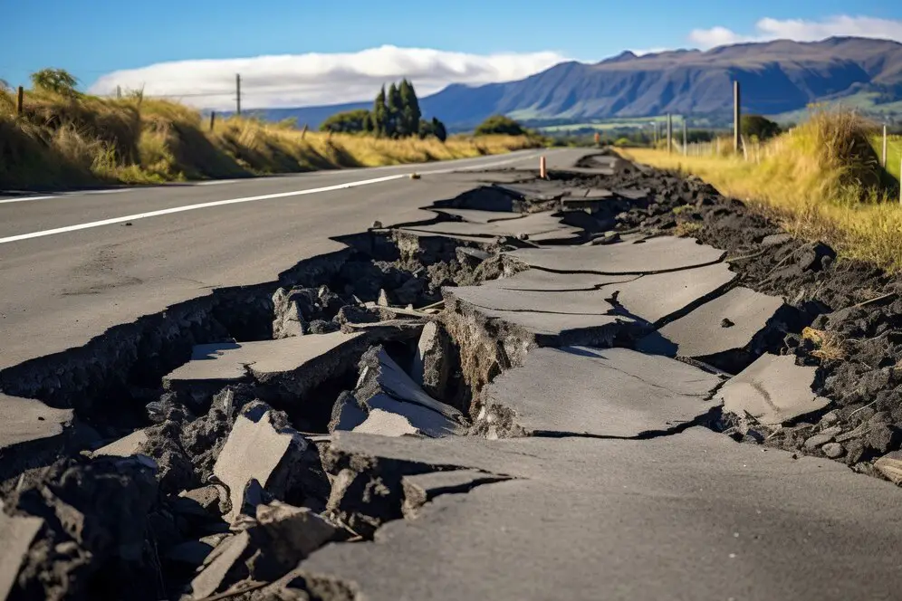
3. Damage Assessment and Public Response
Structural Damage:
-
No reports of collapsed structures or significant infrastructural failures.
-
Minor cracks in drywall and dislodged ceiling tiles reported in a handful of homes and businesses near Van Horn.
Casualties:
-
Zero fatalities or serious injuries confirmed. A small number of individuals sought medical attention for anxiety‐related ailments (e.g., headaches, elevated blood pressure) following the tremors.
Emergency Services:
-
Local fire departments and Texas Division of Emergency Management (TDEM) units remain on alert, conducting aerial and ground patrols for potential damage along rural roadways and around critical infrastructure (e.g., wells, pipelines).
Public Advisories:
-
The USGS and TDEM have issued reminders to “Drop, Cover, and Hold On” during seismic events and to prepare for possible aftershocks.
-
Residents are encouraged to secure heavy furniture, maintain emergency supply kits, and review family communication plans.
4. Historical Seismicity in West Texas
Though not commonly associated with major earthquakes like California or Alaska, Texas—particularly its western counties—has a documented history of moderate‐to‐strong seismic activity:
-
Seventeen games ≥ 5.0 magnitude since 1882, per USGS archives.
-
Largest Recorded Quake: A magnitude‐8.0 event in the Big Bend region in the late 1930s (re‐evaluated from historical accounts and early seismograms).
-
Trend: An uptick in both frequency and average magnitude since the early 2000s, mirroring patterns observed in other central and eastern U.S. regions historically deemed “low‐risk.”
Seismologists emphasize that the Permian Basin’s complex fault network—overprinted by human activity—underlies this latent seismic potential, making West Texas more than just hydrocarbon territory.
5. Underlying Geology: Why West Texas Can Quake
West Texas’s susceptibility to earthquakes stems from its position at the western edge of the stable North American craton, where ancient faults crisscross sedimentary basins:
-
Rio Grande Rift Influence: To the west, crustal stretching generates tectonic stresses that can reactivate faults in adjacent regions.
-
Permian Basin Faults: A legacy of millions of years of deposition, uplift, and erosion, the basin harbors both deep‐seated and near‐surface fault zones.
-
Fault Reactivation: Even small changes in subsurface pressure—natural or induced—can trigger slip on preexisting faults, producing measurable tremors.
This geologic framework explains how a magnitude‐5.4 quake, while atypical, can occur independently of major plate‐boundary interactions.
6. Oil, Gas, and Earthquakes: What the Science Shows
6.1. Hydraulic Fracturing vs. Wastewater Injection
-
Fracturing (“Fracking”): Injects fluid under high pressure to crack rock and release hydrocarbons. Studies show fracking wells rarely induce earthquakes above magnitude 3.0.
-
Deep‐Well Injection: Disposal of produced water (a byproduct of fracking and conventional drilling) into deep, porous formations at high volume and pressure. This practice has been linked to significant seismicity increases in Oklahoma, Kansas, and Texas.
6.2. Quantifying the Link
A 2022 University of Texas at Austin study found that 68% of Texas earthquakes above magnitude 1.5 were “highly associated” with oil‐and‐gas production activities—particularly deep injection into saline aquifers.
“Deep injection wells, in particular, are correlated with larger events because they can alter stress on faults at greater depths,” explains Dr. Alexandros Savvaidis, lead researcher.
6.3. Implications for West Texas
-
Culberson County: Hosts numerous injection wells serving the Delaware Basin.
-
Risk Factors: High injection volumes, proximity to critically stressed faults, and cumulative fluid‐pressure changes increase the odds of moderate to large induced quakes.
While definitive causation for this weekend’s quake has not been established, investigators are closely analyzing injection volumes, pressures, and well locations relative to the epicenter.
7. Regulatory Oversight and Industry Response
7.1. State Regulatory Framework
-
Texas Railroad Commission (RRC): Primary regulator of oilfield injection wells; issues permits, monitors pressures, and is charged with protecting groundwater and public safety.
-
Recent Actions: Following seismic upticks, the RRC has experimented with:
-
Volume limits on new injection wells near known faults
-
Pressure thresholds requiring operators to reduce injection rates if seismicity rates rise
-
Seismic monitoring networks funded by industry levies
-
7.2. Industry Adaptation
Major operators in the Delaware Basin have begun:
-
Reinjection Zoning: Shifting disposal to less‐sensitive formations with lower injection rates.
-
Advanced Monitoring: Installing real‐time seismic arrays to detect micro‐earthquakes and proactively adjust operations.
-
Collaborative Research: Partnering with universities and geological surveys to refine seismic‐hazard models and best‐practice guidelines.
Critics demand more stringent constraints, while producers emphasize the economic imperative of maintaining disposal capacity for byproduct fluids.
8. Enhanced Monitoring and Research Initiatives
Recognizing the evolving risk profile, federal and state agencies are expanding seismic‐monitoring efforts:
-
USGS TexNet Network: A dense array of broadband seismometers across Texas, providing high‐resolution data on small‐magnitude events.
-
University Collaborations: Dr. Savvaidis’s team at UT Austin and the Bureau of Economic Geology are deploying additional sensors near injection clusters.
-
Data Transparency: The RRC now publishes monthly injection and seismicity correlation dashboards—an unprecedented level of public access in Texas.
These measures aim to detect precursory microseismic swarms, refine shallow‐vs. deep‐induced‐earthquake discriminators, and improve regional hazard assessments.
9. Community Preparedness and Building Resilience
While seismic risk remains relatively low compared to urban fault‐zone regions, West Texas residents can take practical steps:
-
Structural Mitigation:
-
Reinforce chimneys, secure bookshelves, install latches on cabinets.
-
Retrofit critical facilities (schools, hospitals) to meet modern seismic standards.
-
-
Emergency Planning:
-
Assemble quake kits with water, non‐perishable food, first‐aid supplies, and flashlights.
-
Establish family communication plans and safe‐room locations.
-
-
Public Education:
-
“Drop, Cover, and Hold On” drills in workplaces and schools.
-
Information campaigns on earthquake insurance—an often‐overlooked coverage in Texas homeowners’ policies.
-
Local governments and community groups are increasingly incorporating seismic scenarios into disaster‐preparedness exercises—a sign of growing institutional awareness.
10. Looking Ahead: Balancing Energy Development and Seismic Safety
West Texas’s economic vitality hinges on the Permian Basin—one of the world’s most productive hydrocarbon regions. However, the friction between resource extraction and seismic risk management demands:
-
Adaptive Regulation: Policymakers must calibrate disposal‐well permitting and injection‐rate controls based on real‐time seismic feedback.
-
Stakeholder Collaboration: Producers, regulators, scientists, and communities need formal mechanisms to share data and co-develop risk‐mitigation strategies.
-
Long-Term Planning: As energy markets shift, authorities should consider transitioning from deep-well disposal toward alternatives like water recycling, treatment, or beneficial reuse—trimming the volume of fluids requiring injection.
If managed proactively, the region can sustain its energy economy while safeguarding residents and critical infrastructure against unexpected tremors.
Conclusion
Saturday’s 5.4-magnitude earthquake in remote West Texas served as a stark reminder that even sparsely populated areas are not immune to significant seismic events. Although no major damage or injuries have been reported, the episode has galvanized attention to the interplay of natural tectonic forces and human activities—particularly deep-wastewater injection.
Strengthened monitoring networks, evolving regulatory frameworks, and collaborative research efforts now offer a path to minimize induced-seismicity risks without forgoing the economic benefits of hydrocarbon production. For residents, the quake underscores the importance of preparedness: securing homes, assembling emergency supplies, and understanding safety protocols.
As West Texas continues to navigate its dual identity—both energy powerhouse and nascent seismic hot spot—the lessons learned in the coming weeks and months will inform policies ensuring that future tremors, whether natural or induced, remain manageable rather than catastrophic.

Adrian Hawthorne is a celebrated author and dedicated archivist who finds inspiration in the hidden stories of the past. Educated at Oxford, he now works at the National Archives, where preserving history fuels his evocative writing. Balancing archival precision with creative storytelling, Adrian founded the Hawthorne Institute of Literary Arts to mentor emerging writers and honor the timeless art of narrative.