Mount Rainier Seismic Activity: Understanding Earthquake Swarms and Volcanic Monitoring
Recent Seismic Events Prompt Increased Scientific Observation
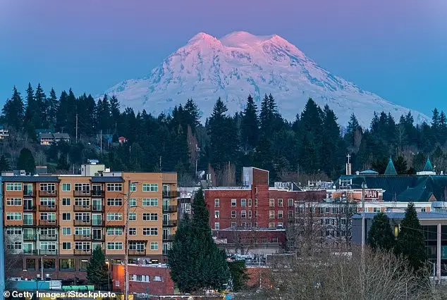
In the early hours of Tuesday morning, Mount Rainier, one of the most closely monitored volcanoes in the United States, experienced a significant swarm of seismic activity that has captured the attention of geological researchers and emergency management officials throughout the Pacific Northwest. The United States Geological Survey (USGS) reported that beginning at 4:29 AM Eastern Time, hundreds of small earthquakes began occurring beneath the massive stratovolcano, marking the most substantial seismic event recorded at the site since 2009.
The earthquake swarm, while notable for its frequency and timing, consisted entirely of relatively minor tremors, with none exceeding 1.7 in magnitude. All recorded seismic events occurred at depths ranging from 1.2 to 3.7 miles below Mount Rainier’s summit, representing what geological experts consider to be relatively shallow earthquake activity. This shallow depth is significant because it suggests the seismic events are occurring within the volcanic system itself, rather than in the deeper crustal structures that typically generate tectonic earthquakes.
Despite the intensity of the seismic activity, officials from the USGS Cascades Volcano Observatory (CVO) have emphasized that current monitoring data does not indicate an imminent eruption. The volcano’s alert level remains at “normal,” and comprehensive instrumental monitoring has not detected any ground deformation or anomalous signals from infrasound monitoring stations that would typically precede significant volcanic activity.
Historical Context and Ongoing Monitoring
The recent earthquake swarm represents just the latest chapter in Mount Rainier’s ongoing geological activity. According to USGS data, the volcano has experienced hundreds, and possibly thousands, of small earthquakes since 2020, indicating that low-level seismic activity has been a consistent feature of the mountain’s behavior in recent years. However, the concentration and frequency of Tuesday’s earthquakes distinguish this event from the background seismic activity that researchers have come to expect.
Mount Rainier stands as one of the most active volcanoes in the Pacific Northwest’s Cascade Range, a volcanic arc that extends from Northern California to British Columbia. The Cascade Range represents one of the most geologically active regions in North America, formed by the subduction of the Juan de Fuca Plate beneath the North American Plate. This ongoing geological process has created a chain of potentially dangerous volcanoes, including Mount St. Helens, Mount Baker, and Mount Rainier, each of which poses unique risks to surrounding communities.
The mountain’s volcanic history spans thousands of years, with geological evidence indicating numerous eruptions and volcanic events throughout its development. While Mount Rainier has not produced a significant eruption in more than 1,000 years, this relative quiet period does not diminish the potential for future activity. Volcanic systems can remain dormant for centuries or millennia before returning to active phases, making continuous monitoring essential for public safety.
Understanding Volcanic Hazards and Risk Assessment
What makes Mount Rainier particularly concerning to volcanologists and emergency management officials is not just its potential for eruption, but the specific nature of the hazards it poses to surrounding communities. The volcano looms over approximately 90,000 people living in major metropolitan areas including Seattle, Tacoma, and Yakima in Washington, as well as Portland, Oregon. This population density in proximity to an active volcano creates a complex risk scenario that requires sophisticated monitoring and emergency planning.
Dr. Jess Phoenix, a respected volcanologist and ambassador for the Union of Concerned Scientists, has characterized Mount Rainier as a source of significant concern, stating that the volcano “keeps me up at night because it poses such a great threat to the surrounding communities.” This assessment reflects the scientific consensus that Mount Rainier represents one of the highest-risk volcanic systems in the United States, not necessarily because of the likelihood of eruption, but because of the potential consequences should an eruption occur.
The primary hazard associated with Mount Rainier is not the dramatic lava flows or ash clouds that many people associate with volcanic eruptions, but rather the formation of lahars—violent, fast-moving mudflows that can devastate entire communities within minutes. These geological phenomena represent one of the most dangerous aspects of volcanic activity, capable of traveling dozens of miles from their source and maintaining destructive power throughout their journey.
The Science and Danger of Lahars
Lahars form when volcanic eruptions rapidly melt the snow and ice that covers Mount Rainier’s slopes, creating massive volumes of water that mix with loose volcanic debris, soil, and rock. This combination creates a concrete-like slurry that can flow at speeds of up to 40 miles per hour, carrying boulders, trees, and debris while maintaining enough force to demolish buildings and infrastructure.
The geological record provides compelling evidence of past lahar activity at Mount Rainier. Cities like Tacoma and South Seattle are built upon deposits of ancient mudflows that originated from previous eruptions of the volcano, indicating that these populated areas lie directly within the path of potential future lahars. These geological formations, some reaching depths of 100 feet, serve as a stark reminder of the volcano’s capacity to affect areas far from its summit.
Historical examples from other volcanic systems worldwide demonstrate the devastating potential of lahars. The 1985 eruption of Nevado del Ruiz in Colombia provides perhaps the most tragic illustration of lahar danger. Within hours of the eruption, a torrent of mud, melted snow, and rock inundated the town of Armero, killing an estimated 25,000 people and causing economic damages exceeding $1 billion. This event, known as the Armero tragedy, remains the costliest volcanic disaster in recorded history and serves as a sobering reminder of the speed and destructive power of volcanic mudflows.
Closer to home, the 1980 eruption of Mount St. Helens, located just 50 miles from Mount Rainier, demonstrated the lahar threat within the Cascade Range. The St. Helens eruption produced mudflows that destroyed more than 200 homes, obliterated 185 miles of roadway, and contributed to a total death toll of 57 people. This event provided valuable insights into lahar behavior and highlighted the importance of preparedness for similar events at other Cascade volcanoes.
Advanced Monitoring and Detection Systems
In response to the recognized threat posed by Mount Rainier, scientists and emergency management officials have developed sophisticated monitoring systems designed to provide early warning of volcanic activity and lahar formation. The Mount Rainier Lahar Detection System represents one of the most advanced volcanic monitoring networks in the world, incorporating cutting-edge technology to track seismic activity, ground deformation, and other indicators of volcanic unrest.
The monitoring system consists of strategically placed seismometers and other instruments positioned on the volcano’s slopes and along vulnerable lahar pathways, including the Puyallup and Tahoma Creek drainages. These instruments continuously monitor for signs of volcanic activity, ground movement, and the formation of lahars. When the system was first established in 1998, technological limitations resulted in significant delays between when a lahar was triggered and when instruments could detect and report the event.
However, substantial upgrades over the past two decades have dramatically improved the system’s effectiveness. Modern technology now allows for real-time monitoring and rapid communication of threats to emergency management officials and the general public. This technological advancement is crucial because lahars can form and travel with such speed that every minute of warning time can be critical for evacuation and emergency response efforts.
The monitoring network also includes infrasound stations that detect low-frequency sound waves generated by volcanic activity, GPS stations that measure ground deformation, and gas sensors that monitor changes in volcanic emissions. This comprehensive approach provides scientists with multiple indicators of volcanic activity, allowing for more accurate assessment of threat levels and more timely warnings to at-risk communities.
Community Preparedness and Emergency Planning
Recognition of the lahar threat has prompted extensive emergency planning and community preparedness efforts throughout the Mount Rainier region. Local governments, emergency management agencies, and school districts have developed comprehensive evacuation plans and conducted regular drills to ensure that residents know how to respond quickly and effectively in the event of volcanic activity.
One of the most significant preparedness efforts occurred on March 21, 2024, when more than 45,000 students in communities south of Seattle and west of Mount Rainier participated in what the USGS described as the world’s largest lahar evacuation drill. This massive exercise involved multiple school districts and emergency agencies working together to practice evacuation procedures and test communication systems that would be crucial during an actual emergency.
These preparedness efforts extend beyond schools to include businesses, healthcare facilities, and residential communities. Emergency management officials have developed detailed maps showing lahar inundation zones and evacuation routes, while public education campaigns help residents understand the risks and appropriate responses. The goal is to create a culture of preparedness that enables rapid and organized evacuation should the need arise.
Current Risk Assessment and Future Outlook
While the recent earthquake swarm at Mount Rainier has increased scientific attention on the volcano, current risk assessment indicates that an eruption is not imminent. The USGS maintains that the volcano’s alert level remains at “normal,” and comprehensive monitoring has not detected the ground deformation or other precursory signals that typically precede significant volcanic activity.
However, the scientific consensus remains that Mount Rainier will eventually erupt again, though the timing cannot be predicted with precision. Volcanic systems operate on geological timescales that can span decades, centuries, or millennia, making it impossible to forecast exactly when activity will resume. This uncertainty underscores the importance of maintaining continuous monitoring and emergency preparedness regardless of current activity levels.
The recent seismic activity serves as a valuable reminder that Mount Rainier remains an active volcanic system that requires ongoing attention and respect. While the current earthquake swarm does not indicate imminent danger, it provides an opportunity for communities to review their emergency plans and ensure that monitoring systems are functioning optimally.
Scientific Research and Technological Advancement
Ongoing research at Mount Rainier contributes to broader scientific understanding of volcanic processes and hazard mitigation. Scientists continue to study the volcano’s magma system, eruption history, and lahar formation processes to improve hazard assessment and early warning capabilities. This research not only benefits communities near Mount Rainier but also contributes to volcanic hazard understanding worldwide.
Advanced modeling techniques now allow scientists to simulate potential eruption scenarios and lahar pathways with greater accuracy than ever before. These models help emergency managers develop more effective evacuation plans and assist communities in making informed decisions about land use and development in potentially hazardous areas.
The integration of artificial intelligence and machine learning into volcanic monitoring systems represents the next frontier in hazard detection and warning. These technologies can analyze vast amounts of seismic and other monitoring data to identify patterns and anomalies that might indicate increasing volcanic activity, potentially providing earlier warning of dangerous conditions.
Conclusion: Living with Volcanic Risk
The recent earthquake swarm at Mount Rainier serves as a reminder that millions of people in the Pacific Northwest live in proximity to one of the world’s most potentially dangerous volcanoes. While current monitoring indicates no immediate threat, the event underscores the importance of continued vigilance, scientific monitoring, and community preparedness.
The story of Mount Rainier represents a broader challenge facing communities worldwide that live near active volcanoes. Successfully managing volcanic risk requires a combination of scientific understanding, technological capability, community preparedness, and sustained commitment to monitoring and emergency planning. The Pacific Northwest’s approach to Mount Rainier risk management serves as a model for other volcanic regions, demonstrating how science, technology, and community engagement can work together to protect public safety.
As monitoring technology continues to advance and our understanding of volcanic processes deepens, communities near Mount Rainier can maintain confidence in their ability to respond effectively to future volcanic activity. The recent earthquake swarm, while noteworthy, represents just another chapter in the ongoing story of living with one of nature’s most powerful and unpredictable forces.

Ethan Blake is a skilled Creative Content Specialist with a talent for crafting engaging and thought-provoking narratives. With a strong background in storytelling and digital content creation, Ethan brings a unique perspective to his role at TheArchivists, where he curates and produces captivating content for a global audience.
Ethan holds a degree in Communications from Zurich University, where he developed his expertise in storytelling, media strategy, and audience engagement. Known for his ability to blend creativity with analytical precision, he excels at creating content that not only entertains but also connects deeply with readers.
At TheArchivists, Ethan specializes in uncovering compelling stories that reflect a wide range of human experiences. His work is celebrated for its authenticity, creativity, and ability to spark meaningful conversations, earning him recognition among peers and readers alike.
Passionate about the art of storytelling, Ethan enjoys exploring themes of culture, history, and personal growth, aiming to inspire and inform with every piece he creates. Dedicated to making a lasting impact, Ethan continues to push boundaries in the ever-evolving world of digital content.