A significant earthquake has rattled south-central Alaska, striking dangerously close to Mount Spurr, a volatile volcano that has been showing increasing signs of unrest for months. The seismic event has heightened concerns among scientists and residents about the potential for a major volcanic eruption that could devastate the region and impact hundreds of thousands of people living in nearby Anchorage.
The Seismic Event That Has Scientists Worried
On Wednesday morning at 10:38 AM local time, the earth beneath Alaska’s wilderness trembled as a magnitude 4.6 earthquake struck near the small community of Petersville. While earthquakes of this magnitude are relatively common in seismically active Alaska, this particular event has captured the attention of volcanologists and emergency management officials due to its proximity to Mount Spurr, a volcano that has been exhibiting troubling signs of potential eruption.
The earthquake occurred at a depth of 52.4 miles beneath the surface, approximately 34 miles north of Skwentna and roughly 86 miles from Mount Spurr itself. Despite the considerable distance from major population centers, the seismic waves propagated widely through the region’s geological structure, creating noticeable shaking that was felt across a vast area of south-central Alaska.
The Alaska Earthquake Center’s rapid response team immediately began analyzing the event, noting that the tremors were felt throughout Anchorage and the broader Matanuska-Susitna region. This widespread perception of shaking, despite the earthquake’s relatively modest magnitude, underscores the efficient transmission of seismic energy through Alaska’s complex geological framework.
What makes this earthquake particularly concerning is not its size, but its timing and location. Mount Spurr has been under heightened scientific scrutiny since March, when the Alaska Volcano Observatory elevated the mountain’s alert status due to increasing signs of unrest. The combination of volcanic instability and nearby seismic activity creates a potentially dangerous scenario that could trigger the eruption scientists have been anticipating.
Mount Spurr: A Sleeping Giant Showing Signs of Awakening
Mount Spurr stands as one of Alaska’s most closely monitored volcanoes, and for good reason. Located approximately 78 miles west of Anchorage, this massive stratovolcano has the potential to significantly impact Alaska’s largest metropolitan area, home to nearly 300,000 residents who would face severe consequences from a major eruption.
The volcano’s current status under an “Advisory” alert level reflects the ongoing low-level unrest that scientists have been documenting for months. This designation indicates that the volcano is exhibiting elevated levels of activity above normal background levels, including occasional small earthquakes beneath the volcanic edifice, changes in gas emissions, and other indicators that suggest magma movement deep within the mountain’s plumbing system.
The progression of Mount Spurr’s unrest has been carefully documented by the Alaska Volcano Observatory, which maintains a network of sophisticated monitoring equipment around the volcano. These instruments continuously measure seismic activity, ground deformation, gas emissions, and thermal signatures that can provide early warning signs of an impending eruption.
In March, the situation became significantly more concerning when scientists elevated Mount Spurr to a “Watch” status, indicating that they expected an eruption could occur at any moment. During this period, the volcano began releasing elevated levels of gas from both its main summit crater and the Crater Peak side vent, which was the site of the volcano’s last major eruption in 1992.
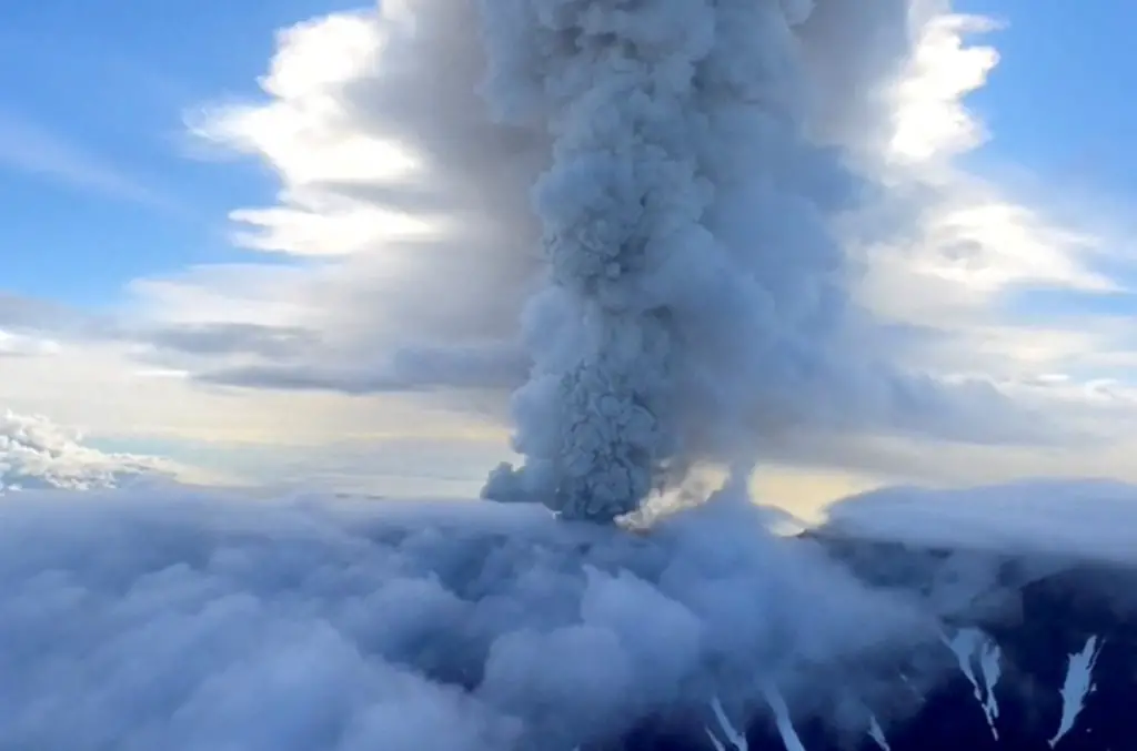
The 1992 eruption serves as a sobering reminder of Mount Spurr’s destructive potential. That event produced massive ash plumes that rose to heights of over 40,000 feet, depositing ash across a wide area and causing significant disruptions to air travel and daily life in south-central Alaska. The eruption also generated pyroclastic flows and lahars that reshaped the volcanic landscape and demonstrated the mountain’s capacity for explosive violence.

The Science Behind Earthquake-Triggered Eruptions
The relationship between earthquakes and volcanic eruptions has been the subject of intensive scientific study, particularly as researchers seek to better understand and predict volcanic behavior. A groundbreaking 2021 study published in the prestigious journal Nature provided crucial insights into this connection, revealing that most volcanoes, especially those already showing signs of unrest like Mount Spurr, can indeed be triggered to erupt by nearby earthquakes.
The mechanism behind earthquake-triggered eruptions involves the complex interaction between seismic waves and volcanic systems. When earthquake waves pass through or near a volcano, they can cause several effects that may destabilize an already primed volcanic system. These effects include the shaking and fracturing of rock formations that contain magma chambers, the disruption of gas bubble distributions within magma, and the potential creation of new pathways for magma to reach the surface.
The study’s findings are particularly relevant to Mount Spurr’s current situation because the volcano has been exhibiting many of the precursor conditions that make earthquake triggering more likely. These conditions include elevated magma pressure within the volcanic system, underground gas buildup that increases internal pressure, and the presence of magma at relatively shallow depths where it can be more easily mobilized by external forces.
The depth of Wednesday’s earthquake—52.4 miles below the surface—places it well within the range where seismic waves can effectively interact with volcanic systems. While deeper earthquakes tend to spread their energy more widely and may feel less violent at the surface, they can still generate the types of pressure waves and stress changes that can influence volcanic behavior.
The timing of this earthquake is particularly significant because it occurs during a period when Mount Spurr is already in a heightened state of unrest. Volcanologists have long observed that volcanic systems showing signs of instability are much more susceptible to external triggers than dormant volcanoes. The presence of mobile magma, elevated gas pressure, and fractured rock systems creates conditions where even relatively modest seismic disturbances can tip the balance toward eruption.
Regional Impact and Community Response
The earthquake’s effects extended far beyond the immediate epicenter near Petersville, with residents across a wide swath of south-central Alaska reporting noticeable shaking. The US Geological Survey received nearly 200 reports of ground motion from the sparsely populated region, indicating the broad reach of the seismic waves despite the earthquake’s moderate magnitude.
In Anchorage, located more than 100 miles from the earthquake’s epicenter, residents in various neighborhoods reported feeling the tremors. Melissa Palmer, posting on social media, noted that she felt the earthquake in the Airport Heights area of Anchorage. Other residents reported similar experiences in the Sand Lake neighborhood and areas north of Healy, demonstrating the wide geographic distribution of the earthquake’s effects.
The fact that such a relatively modest earthquake could be felt across such a large area speaks to the geological characteristics of the region and the efficient transmission of seismic energy through Alaska’s complex rock formations. This widespread perception also highlights the sensitivity of local residents to ground motion, likely heightened by their awareness of both seismic and volcanic hazards in the region.
For the nearly 300,000 residents of the greater Anchorage area, this earthquake serves as a stark reminder of their vulnerability to both seismic and volcanic threats. The city sits in a geologically active region where earthquakes are common, but the added dimension of volcanic risk from Mount Spurr creates a unique set of challenges for emergency preparedness and risk management.
Local emergency management officials have been working closely with scientific monitoring agencies to develop comprehensive response plans for various volcanic eruption scenarios. These plans must account for the potential impacts of ash fall, which could disrupt transportation, utilities, and daily life for extended periods, as well as the broader economic and social consequences of a major eruption.
Geological Context and Seismic Hazards
The region around Petersville, where Wednesday’s earthquake occurred, sits within a complex geological setting that influences both seismic and volcanic activity. The area is affected by the Broad Pass thrust fault, a significant geological feature that represents a southeast-vergent thrust fault system responsible for creating the Peters Hills basin through its tectonic activity.
This fault system is considered active by geologists, meaning it has the potential to generate significant earthquakes that could pose serious hazards to the region. Scientific assessments suggest that the Broad Pass thrust fault could potentially produce earthquakes in the magnitude 7.6 to 7.8 range, which would represent major seismic events with devastating potential for widespread damage and loss of life.
The presence of this active fault system near Mount Spurr adds another layer of complexity to the volcanic monitoring and hazard assessment efforts. The interaction between tectonic activity along the fault and volcanic processes within Mount Spurr creates a dynamic and potentially dangerous geological environment where multiple hazards can interact and amplify each other’s effects.
Understanding these geological relationships is crucial for scientists attempting to assess the likelihood and potential impacts of future volcanic eruptions. The stress changes and ground deformation associated with fault movement can influence volcanic systems, while volcanic activity can also affect the stress distribution along nearby faults, creating feedback loops that complicate hazard prediction and risk assessment.
The depth of Wednesday’s earthquake—more than 50 miles below the surface—places it well within the deeper crustal or upper mantle regions where tectonic processes operate on large scales. Earthquakes at these depths can generate long-period seismic waves that travel efficiently through the Earth’s crust and can be felt at great distances from their source.
Current Monitoring and Scientific Assessment
The Alaska Volcano Observatory continues to maintain intensive monitoring of Mount Spurr using a comprehensive array of scientific instruments and techniques. Their latest assessment, issued on Tuesday before Wednesday’s earthquake, painted a picture of ongoing but relatively stable unrest at the volcano.
According to AVO’s most recent update, “Low-level unrest continues at Mount Spurr with occasional, small earthquakes occurring beneath the volcano.” This characterization indicates that while the volcano remains active and potentially dangerous, the current level of activity does not suggest an imminent eruption threat, though this assessment may need to be revised in light of the recent earthquake.
Satellite imagery analysis has not revealed any new thermal anomalies or significant changes in the volcano’s surface conditions over the past day, suggesting that any magma movement remains confined to deeper levels within the volcanic system. Clear webcam views of Mount Spurr’s summit crater have shown only minor vapor emissions, which are typical for a volcano in a state of low-level unrest.
However, AVO scientists are careful to note that “fluctuations in unrest are common at volcanoes and eruptive activity remains possible, but unlikely.” This cautious assessment reflects the inherent difficulty in predicting volcanic behavior, even with sophisticated monitoring systems and extensive historical data.
The agency’s analysis draws on important lessons from Mount Spurr’s 1992 eruption, when there were periods of decreased unrest before the eventual explosive events. Significantly, these quiet periods were not sustained, and seismic activity fluctuated considerably in the lead-up to the actual eruption, demonstrating that volcanic systems can exhibit complex and sometimes deceptive behavior patterns.
Potential Eruption Scenarios and Impacts
Based on the volcano’s history and current monitoring data, scientists have developed detailed scenarios for potential future eruptions at Mount Spurr. Matt Haney, scientist-in-charge at the Alaska Volcano Observatory, has provided sobering assessments of what such an eruption might entail and its potential consequences for the region.
The most likely eruption scenario involves activity at the Crater Peak side vent, which was the site of the 1992 eruption and has been showing increased gas emissions during recent months of unrest. According to Haney’s analysis, such an eruption would likely be explosive in nature, producing the types of dramatic and dangerous volcanic phenomena that can have far-reaching impacts.
An explosive eruption at Crater Peak would generate multiple ash plumes that could rise to heights of 50,000 feet or more into the atmosphere. These towering columns of volcanic ash, rock fragments, and gas would pose immediate threats to aviation in the region while also creating the potential for widespread ash fall across populated areas.
Each explosive episode is expected to last approximately three to four hours, during which continuous ash emission would create growing clouds of volcanic debris that would be carried by prevailing wind patterns. Depending on wind conditions at the time of eruption, these ash clouds could blanket Anchorage and other nearby communities in thick layers of abrasive volcanic dust.
The impacts of ash fall on urban areas can be severe and long-lasting. Even relatively thin accumulations of volcanic ash can disrupt transportation systems, damage machinery and electronics, contaminate water supplies, and pose serious health risks to residents, particularly those with respiratory conditions. Thicker ash deposits can cause building collapses due to the weight of accumulated material and can render roads and airports unusable for extended periods.
Beyond ash fall, an explosive eruption at Mount Spurr would also generate other dangerous volcanic phenomena. Pyroclastic flows—fast-moving avalanches of hot gas, ash, and volcanic debris—could race down the volcano’s slopes at speeds exceeding 200 miles per hour, destroying everything in their path.
The eruption would also likely produce destructive mudslides known as lahars, which form when volcanic debris mixes with water from melted snow and ice or from heavy rainfall. These concrete-like flows can travel for miles from the volcano, following river valleys and potentially reaching areas far from the volcanic source.
Fortunately, as Haney noted, there are no communities within the immediate radius that would be directly affected by pyroclastic flows and lahars from Crater Peak. However, the broader regional impacts from ash fall and other volcanic hazards could still affect hundreds of thousands of people across south-central Alaska.
Emergency Preparedness and Response Planning
The ongoing volcanic unrest at Mount Spurr has prompted extensive emergency preparedness efforts across south-central Alaska, with local, state, and federal agencies working together to develop comprehensive response plans for various eruption scenarios. These planning efforts must account for the unique challenges posed by Alaska’s geography, climate, and infrastructure limitations.
The Municipality of Anchorage has been particularly active in updating its volcanic hazard response procedures, recognizing that the city’s residents and economy would bear the brunt of impacts from a major Mount Spurr eruption. Emergency managers have been working to educate the public about volcanic hazards and the steps residents should take to protect themselves and their property in the event of an eruption.
Key preparedness measures include the stockpiling of emergency supplies, the development of evacuation procedures for areas that might be affected by lahars or flooding, and the creation of communication systems that can function even when ash fall disrupts normal telecommunications infrastructure. Hospitals and other critical facilities have been reviewing their procedures for dealing with respiratory health impacts from volcanic ash exposure.
The aviation industry faces particular challenges from volcanic ash, as the abrasive particles can damage aircraft engines and pose serious safety risks to flight operations. Ted Stevens Anchorage International Airport, a crucial hub for both passenger and cargo flights, has developed detailed procedures for dealing with ash fall events, including the suspension of operations when ash concentrations reach dangerous levels.
Economic preparedness is another crucial aspect of volcanic hazard planning, as a major eruption could disrupt Alaska’s economy for weeks or months. The tourism industry, fishing operations, and oil production facilities all face potential impacts from volcanic activity, requiring contingency planning and risk mitigation strategies.
https://www.dailymail.co.uk/sciencetech/article-14977313/Earthquake-strikes-volcano-anchorage-alaska.html#v-4712569533995043463
Historical Context and Lessons Learned
Mount Spurr’s 1992 eruption provides crucial historical context for understanding the potential impacts of future volcanic activity. That event, which occurred over several months with multiple explosive episodes, demonstrated both the destructive power of the volcano and the resilience of Alaskan communities in responding to volcanic disasters.
The 1992 eruption produced ash clouds that reached heights of over 40,000 feet and deposited ash across a vast area of south-central Alaska. Anchorage experienced significant ash fall that disrupted daily life, closed the airport for several days, and caused millions of dollars in economic losses. The eruption also affected air quality across the region and required extensive cleanup efforts that continued for months after the volcanic activity ended.
One of the most important lessons learned from the 1992 eruption was the critical importance of accurate and timely scientific monitoring and public communication. The Alaska Volcano Observatory’s monitoring network, which was less comprehensive in 1992 than it is today, provided valuable but sometimes limited information about the eruption’s progression, leading to improvements in monitoring capabilities and communication protocols.
The 1992 event also highlighted the interconnected nature of modern society’s vulnerability to natural disasters. The disruption of air travel affected not just local transportation but also cargo shipments that supply Alaska’s remote communities. The economic impacts extended far beyond the immediate region, affecting businesses and individuals across Alaska and beyond.
These historical lessons have informed current preparedness efforts and scientific monitoring strategies. The expanded monitoring network now surrounding Mount Spurr provides much more detailed and real-time information about volcanic conditions, potentially allowing for better prediction of eruption timing and characteristics.
Climate and Environmental Implications
A major eruption at Mount Spurr would have environmental implications extending far beyond the immediate volcanic hazards. Volcanic eruptions can affect regional and even global climate patterns through the injection of ash and sulfur compounds into the atmosphere, where they can influence weather patterns and solar radiation absorption.
The 1992 Mount Spurr eruption provided scientists with valuable data about these atmospheric effects, showing how volcanic emissions can create localized cooling effects and influence precipitation patterns across Alaska. A larger future eruption could have more significant and longer-lasting atmospheric impacts, potentially affecting weather patterns across the North Pacific region.
The environmental impacts on Alaska’s ecosystems would also be substantial. Ash fall can damage or kill vegetation, contaminate water sources, and disrupt wildlife habitats. The region’s salmon runs, which are crucial to both ecological systems and human economies, could be particularly vulnerable to volcanic impacts on stream and river systems.
Recovery of natural systems from volcanic impacts can take years or decades, with some areas potentially experiencing permanent ecological changes. However, volcanic eruptions also create new landforms and can ultimately contribute to soil fertility and ecosystem diversity over longer time scales.
Looking Forward: Ongoing Vigilance and Scientific Advancement
As Mount Spurr continues to show signs of unrest and Wednesday’s earthquake serves as a reminder of the dynamic geological forces at work in the region, scientists and emergency managers must maintain constant vigilance while continuing to advance their understanding of volcanic processes and hazard prediction.
The Alaska Volcano Observatory’s monitoring efforts represent the state of the art in volcanic surveillance, but there is always room for improvement in both the technology used to monitor volcanic activity and the scientific understanding of how volcanic systems behave. Advances in satellite technology, ground-based monitoring equipment, and computer modeling continue to enhance scientists’ ability to track volcanic unrest and assess eruption probabilities.
Research into earthquake-volcano interactions, such as the type of relationship that may be relevant to Wednesday’s earthquake near Mount Spurr, remains an active area of scientific investigation. Better understanding of these processes could improve scientists’ ability to assess how seismic events might influence volcanic eruption timing and intensity.
The integration of multiple monitoring techniques—including seismic monitoring, gas emission measurements, satellite imagery, and ground deformation studies—provides a comprehensive picture of volcanic conditions that is far more detailed and reliable than any single monitoring approach. This integrated approach will be crucial for providing the most accurate possible assessments of Mount Spurr’s future behavior.

Conclusion: Living with Volcanic Risk in Alaska
Wednesday’s magnitude 4.6 earthquake near Mount Spurr serves as a compelling reminder of the complex and potentially dangerous geological environment that characterizes much of Alaska. While the earthquake itself was not unusually large by Alaskan standards, its occurrence near a volcano already showing signs of unrest highlights the interconnected nature of geological hazards and the ongoing challenges faced by communities living in volcanically active regions.
The situation at Mount Spurr exemplifies the delicate balance between the benefits and risks of living in geologically dynamic environments. Alaska’s dramatic landscapes, abundant natural resources, and unique ecosystems are all products of the same geological forces that create volcanic and seismic hazards. For Alaskans, learning to live with these risks while maintaining vibrant communities and economies requires ongoing vigilance, scientific understanding, and comprehensive preparedness efforts.
The scientific monitoring and emergency preparedness infrastructure that has been developed around Mount Spurr represents a significant investment in public safety and reflects lessons learned from past volcanic events. The Alaska Volcano Observatory’s continuous monitoring efforts, combined with emergency management planning at local, state, and federal levels, provide the foundation for effective response to future volcanic activity.
As Mount Spurr continues its current period of unrest, with the added concern of nearby seismic activity, the importance of maintaining and improving these monitoring and preparedness systems becomes even more apparent. The volcano’s proximity to Alaska’s largest population center means that hundreds of thousands of people have a direct stake in understanding and preparing for potential volcanic hazards.
The ongoing situation also underscores the broader significance of volcanic hazards in Alaska, where numerous active volcanoes pose potential threats to communities, transportation systems, and economic activities across the state. Mount Spurr may be receiving the most attention currently due to its proximity to Anchorage, but Alaska’s volcanic arc contains dozens of potentially active volcanoes that require ongoing scientific attention and hazard assessment.
Looking ahead, the combination of advancing scientific understanding, improving monitoring technology, and enhanced emergency preparedness provides reasons for cautious optimism about Alaska’s ability to manage volcanic risks effectively. While volcanic eruptions remain inherently unpredictable and potentially devastating natural phenomena, the investments made in scientific monitoring and community preparedness offer the best possible foundation for protecting lives and minimizing impacts when future eruptions occur.
For now, residents of south-central Alaska continue to watch and wait as scientists monitor Mount Spurr’s ongoing unrest and assess the potential implications of Wednesday’s earthquake. The volcano’s behavior in the coming weeks and months will provide crucial information about the relationship between seismic activity and volcanic processes, while also testing the effectiveness of the monitoring and preparedness systems that have been put in place to protect public safety.
The story of Mount Spurr’s current unrest is still being written, with each new piece of monitoring data and each seismic event adding to scientists’ understanding of this complex and potentially dangerous volcanic system. As this story continues to unfold, it serves as a powerful reminder of the dynamic geological forces that shape Alaska’s landscape and the ongoing vigilance required to live safely in one of the world’s most volcanically active regions.

Adrian Hawthorne is a celebrated author and dedicated archivist who finds inspiration in the hidden stories of the past. Educated at Oxford, he now works at the National Archives, where preserving history fuels his evocative writing. Balancing archival precision with creative storytelling, Adrian founded the Hawthorne Institute of Literary Arts to mentor emerging writers and honor the timeless art of narrative.